Developing energy resources in checkerboard land
By Bryan Leonard
Imagine that you are a private landowner interested in tapping oil or gas reserves beneath your property. You own one square mile of land, which is surrounded by alternating squares of federal and private land. You may even own many square miles of land, but they only meet at the corners, because you live in a part of the country called the checkerboard, which arose from federal land grants made to railroad companies in the 1800s.
Many of the landscapes beset with this fragmented ownership pattern also happen to hold vast energy resources, ranging from oil and gas to wind and solar. These resources—and the infrastructure needed to develop them—are often larger than the one-by-one-mile squares within the checkerboard, and the consequences for energy development can be significant due to regulatory spillover from adjacent public land.
Odds are, the Bureau of Land Management (BLM) is in charge of the federal squares around you, both the surface estate, meaning the right to use what is aboveground, and the mineral estate, meaning the rights to belowground resources. The BLM administers oil and gas development across 700 million acres of public land, but in the checkerboard, its decisions about which areas to lease and under what conditions—along with parallel decisions made by federal agencies regarding surface use—have a substantial impact on private land as well.
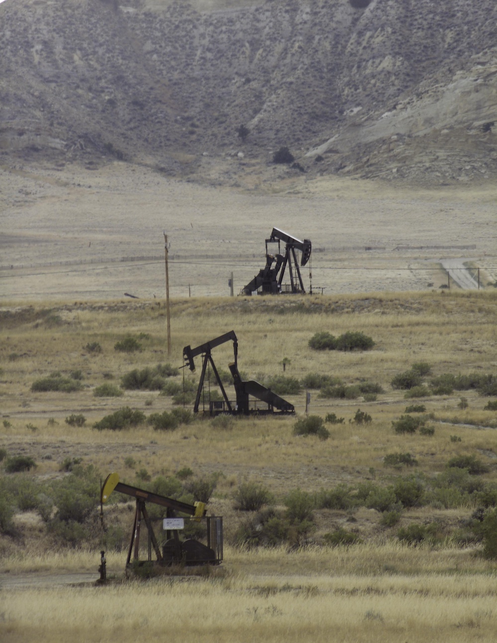
lands than on federal lands. In the checkerboard, regulatory
spillover from the public parcels can impact the adjacent
private squares. (US Department of Energy)
Analysis of energy development on public versus private land in Wyoming indicates that those impacts are likely economically negative but environmentally positive. That is, the complex web of regulations that governs federal land makes energy development significantly slower and more costly than on private lands, but is also correlated with lower rates of, for example, oil and water spills. These regulations include the 1920 Mineral Leasing Act, the 1970 National Environmental Policy Act, and the 1976 Federal Land Policy and Management Act. The extent of these impacts varies based on the type of energy development, the amount of pre-existing infrastructure, and the nature of potential environmental impacts.
For example, conventional oil and gas drilling on private land is often not directly affected by federal restrictions within the checkerboard in Wyoming because the state’s regulations for drilling are built around the operation of “spacing units,” which are usually only a square mile in size. Hence, the typical scale of development happens to exactly match the size of the squares in the checkerboard, and operators and regulators can make decisions one square at a time without directly affecting the operations on adjacent squares. This is likely neither accidental nor intentional, but rather a natural result of the Public Land Survey System dividing the whole western US into a grid of square-mile sections. The federal government used this grid to delineate the size and boundaries of the railroad grants, and the system is close enough to the approximate scale for conventional drilling that it made the most sense administratively to define units this way.
The advent of horizontal drilling and hydraulic fracturing, however, has upended this reality. A typical lease for a horizontal fracking project is one mile wide and anywhere from two to three miles long, which would require a row of several adjacent squares on a checkerboard. Hence, an operator would need to lease both private and federal minerals to assemble the acreage for a single well pad. If regulation makes leasing federal mineral acreage in the checkerboard difficult or impossible, the adjacent private mineral rights may not be economical to extract on their own, significantly reducing their value.
Research published in The Economic Journal confirms this, comparing oil production under different ownership patterns during the 2010–2015 fracking boom in the Bakken shale formation that underlies the Fort Berthold Indian Reservation in North Dakota. Similar to the checkerboard, historical federal policies have created a mosaic of parcels of varying sizes and owners—fee simple lands with one private owner, allotted trust land co-owned by multiple owners (with an average of 17 owners per parcel), and land held by the Tribal government.
Of note, most of the single and co-owned parcels are less than the two square miles needed to make shale oil extraction profitable, because of how allotment played out under the Dawes Act of 1887. The act initiated privatization across many reservations, taking land that was communally owned by Tribes and giving it to individual Tribal members (leading to fee simple lands with single owners). At first, however, parcels were held in trust until allottees were deemed “competent.” When the Indian Reorganization Act ended allotment in 1934, many parcels became stuck in trust, and a practice of passing those parcels to all of an allottee’s heirs has led to allotted trust parcels with more than 100 owners today.
Comparing oil production per acre across 8,000 parcels on the reservation—based on their size, ownership type, and the fragmentation of surrounding land—indicates that joint ownership and small, interspersed parcels of federal and private land had the most significant negative impacts on productivity. In particular, the presence of a small government holding near a private parcel cut expected production nearly in half.
Interestingly, this analysis also indicated that there is a threshold at which the higher costs of developing on government land are surpassed by the transactional cost of doing business with many individual private landowners. So, in the checkerboard, where federal and private lands are equally fragmented, private land tends to be more productive, but on Fort Berthold, larger, contiguous blocks of government land were more productive than many small parcels with many different owners. In fact, if all the allotted trust lands on the reservation had been consolidated into Tribal ownership, estimates show that the same land might have produced $90 million more in initial royalty earnings during the boom.

Beyond the ownership of minerals themselves, and the need to have enough space to make production viable and economic, there is also the matter of access and transport. In this, the issuance of rights-of-way on federal land can have a substantial impact on all forms of energy development on adjacent private land. Even when conventional oil and gas projects are feasible within square-mile tracts of private minerals, rights-of-way must be obtained across adjacent federal lands to install the necessary roads and pipelines to move drilling SAME BOARD, NEW GAME equipment in and bring the oil and gas out. Land use plans, like the BLM’s Resource Management Plans, will typically designate areas as “open,” “avoidance,” and “closed” for rights-of-way, depending on other resource goals like protecting sensitive habitat, historic trail corridors, or viewsheds. Avoidance areas can make it very difficult to obtain a right-of-way permit, and even open areas can still be subject to additional stipulations.
This same problem creates roadblocks to renewable energy development, for two reasons. First, installing high-voltage transmission lines across federal lands has long required surface rights-of-way. Hence, even for relatively small, utility-scale solar installations that can be less than one square mile, the inability to connect projects to the grid can render checkerboard development infeasible. The second reason is that, in the absence of specific federal legislation to create a framework for renewable development on federal land, the BLM and US Forest Service have opted to issue permits for wind and solar development as rights-of- way grants. This means that any renewable energy project with a footprint larger than a square mile would require federal rights-of-way for development within the checkerboard.

Although the spillover effects of federal regulation onto private energy development can be large—especially in places like Wyoming where significant fossil fuel and renewable energy resources overlap the checkerboard—these impacts are often given short shrift or overlooked altogether in federal planning processes. For instance, the draft version of the recent Rock Springs Resource Management Plan in southwest Wyoming entailed significant changes to federal land management within the checkerboard, but the 1,500-page environmental impact statement contained no analysis of potential impacts to private lands. My calculations indicate that the BLM’s preferred alternative would have potentially blocked access to an additional 502,000 acres of private surface and 231,000 acres of private minerals. However, the final version of the plan dramatically reduced rights-of-way exclusions of federal land, leading to much more modest impacts in the checkerboard.
Energy resources—like many other valuable natural assets—are highly site-specific. A geologic formation either contains valuable fossil fuels and other minerals, or it doesn’t. Similarly, the renewable energy potential of a particular location is largely fixed, given current technology. The scale of these resources often does not conform to administrative boundaries and landownership patterns, especially in the checkerboard. When this happens, resources are often developed less productively, at higher cost, or not at all. As the US energy generation mix increasingly moves toward renewable sources with larger footprints, the importance of accounting for private-land impacts of federal regulations in the checkerboard will only grow.
Bryan Leonard is an associate professor of environmental and natural resource economics and the SER Chair of Environment and Natural Resources in the Haub School of Environment and Natural Resources and the School of Energy Resources at the University of Wyoming. He is also an affiliate of the Environmental Markets Lab at UC Santa Barbara and the Ostrom Workshop at the University of Indiana.