Encampment River Case Study
A front loader picks up massive boulders as if they are pebbles. A bulldozer shoves rocks into a mound. High-pitched beeps ebb and flow as the machinery works back and forth. Everything about this construction site is typical, with one exception: the equipment is in the middle of the Encampment River. The front loader bucket dips into the water, scrapes along the riverbed, and scoops up cobbles and sediment.
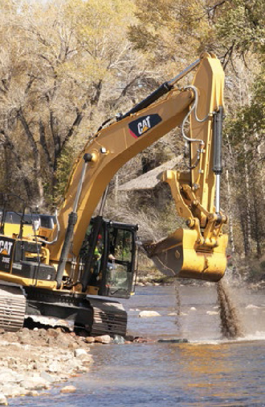
Water streams over the edges as the bucket lifts and swivels towards the stream bank. With one deft movement, the heavy machinery dumps the cobbles and sediment. The rocks crash and boom to the riverbank. River reconstruction is under way.
Many rivers today are not the same wild waterways they once were. Throughout human history, civilizations have struggled to transport, store, use, and control water, and these actions have restructured our watersheds. In some cases, manipulation has resulted in sick rivers—straightened, widened, and degraded until they no longer provide critical ecosystem services such as efficiently moving sediment and water. Across the West, conservation groups, private landowners, federal and state agencies, and construction companies are working together to enhance river function.
To see an example of river enhancement, I drove to Riverside, Wyoming, to meet Christina Barrineau, an aquatic habitat biologist with the Wyoming Game and Fish Department. Wearing hiking boots, a fleece pullover, and large black sunglasses, she greeted me with a smile and a firm handshake at the Bear Trap Restaurant, where I climbed into her pickup truck. Barrineau restores and enhances watersheds throughout Wyoming, and has most recently been overseeing work on the Encampment River. As we drove to the first site, Barrineau told me the river’s story.
Like many western rivers, the Encampment is, in Barrineau’s words, “well-used.” During construction of the transcontinental railroad in the nineteenth century, workers harvested trees along the upper Encampment River, cut them into railroad ties, and floated them down the river. The ties filled the entire channel, scouring the bottom of the river. In 1897, prospectors built a diversion dam in the Encampment River to supply water to a copper smelter. Sediment built up above the diversion dam, and downstream water from the smelter rushed out of a pipeline and degraded the stream banks.
Diversions for agriculture also damaged the river. Cobble push-up dams, built to force water into irrigation ditches, restricted the river’s flow and prevented fish from moving upstream. The push-up dams couldn’t withstand spring floods, so every year workers bulldozed the riverbed back up. Another agricultural use, cattle grazing, has reduced streamside vegetation, leading to bank erosion.
The combined historic uses of the watershed have created a stream unable to heal itself. In one section of the river, the bank eroded forty feet in one year, cutting into an adjacent pasture. Private landowners along the Encampment River have tried to reduce bank erosion to save their property. One landowner cabled hundreds of tires to the riverbank, while others threw rocks, trees, and car bodies in the water to break up and slow the powerful current. These structures have not held up. Over time, they have fallen apart while erosion has put private property at risk and the river channel sprawls and becomes shallower. Barrineau’s description of the river as “well-used” is an understatement.
Charlie Reinertsen
As the truck approached the first construction site, Barrineau explained that a river has two roles: to move water and to move sediment. A “healthy” river has deep channels with fast-moving current broken up by eddies and pools. The channels meander and even shift paths or directions over time. Intact riparian habitat, the vegetation on the banks of a river, filters run-off and provides stability to the riverbanks. Spring floods move sediment through the system, maintaining the deep channels. A healthy river runs wild.
The Encampment River running through Riverside does not paint the picture of a healthy river. The channel is shallow and wide. Native vegetation is missing from large stretches of the banks, and the banks crumble into the water. Undercut banks loom over the river, waiting to fall and add more sediment to the already shallow channel. Levies, dams, irrigation ditches, and droughts prevent spring floods from sweeping the river clean. Without regular floods, the river cannot carve deeper channels or move sediment from the streambed to the flood plain. This shallow, wide, eroding river is not just “well-used”; it is painfully sick.
In an attempt to tame rambunctious waters, humans have removed many rivers’ ability to heal themselves, requiring even more management to engineer river recovery. Early “hard” engineering methods disregarded a river’s natural function and ecology. These engineers straightened and widened streams to gain complete control over the waters. A shift in river management occurred in the 1950s when hard engineering gave way to fluvial geomorphology, or the study of a river’s natural function to inform ecological restoration.
One fluvial geomorphologist, Dave Rosgen, has heavily influenced river enhancement throughout the country. Rosgen recieved a PhD in geomorphology and hydrology and started his career as a hydrologist for the Forest Service. After working for the Forest Service, Rosgen started a river restoration consulting firm and developed a straightforward river enhancement method called Natural Channel Design. Natural Channel Design studies unimpaired rivers and applies ideas from fluvial geomorphology to restore function to impaired rivers. Over the past twenty-five years, Rosgen has honed Natural Channel Design by developing and testing the techniques on hundreds of river restoration projects. He also developed a four-part course and certification program, and has taught over 17,000 people Natural Channel Design theory and methodology.
On the Encampment River, since 2011 Barrineau has been overseeing contractors trained in Natural Channel Design methods. The work doesn’t come for free. This enhancement project is a collaborative effort between the Wyoming Wildlife and Natural Resource Trust, the Wyoming Game and Fish Department, the Saratoga-Encampment-Rawlins Conservation District, Trout Unlimited, the Natural Resource Conservation Service, the US Fish and Wildlife Service, the US Forest Service Resource Advisory Committee, the Wyoming Governor’s Big Game License Coalition, the Wyoming Landscape Conservation Initiative, private landowners, the Encampment School, and volunteers. Together, these groups have been restoring two contiguous river segments spanning nearly 6,000 feet at the cost of roughly $200 per liner foot, or $1.2 million.
When Barrineau’s truck pulls up, the bulldozer and front loader are working in the river, beeping as they move cobbles from the streambed to the bank, repairing structures damaged by unusually high spring floods. A curve of massive boulders in the riverbed extends upstream from one bank and curls around to the opposite bank, creating rapids and a deep channel downstream. Barrineau explains it is a J-hook designed to centralize flows and keep the river from gnawing at the banks.
Rosgen designed structures such as the J-hook to help maintain or create the dimension (the depth and width of the river), pattern (the extent of meandering), and profile (the slope) of a river. Natural Channel Design includes a classification system that can be used to describe different types of rivers. Restoration work on an impaired river is then modeled after an unimpaired river of the same classification.
After classifying a river, a Natural Channel Design project would involve measuring bank erosion rates and other factors to describe the river impairment. After that, the next step is to define the objectives of the project, which may include improving fisheries or aesthetic appearance, reducing land loss and erosion, or increasing sediment transport. On the Encampment River, the primary objectives were to transport sediment and reduce land loss from erosion, and a secondary goal was fishery improvement. The last step is for workers to reconstruct a channel by selecting structures to create the dimension, pattern and profile to meet the objectives.
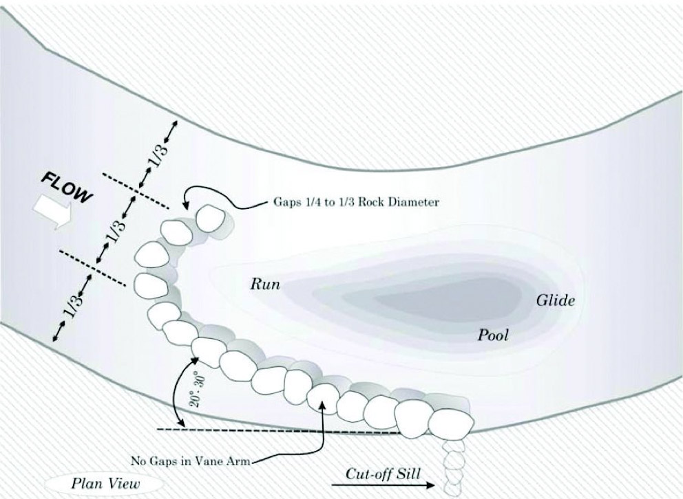
The J-hook we’re looking at was one of the first structures built here. Barrineau is critical of her early work, warning me, “Don’t take notes here. You will see better examples later today.” River enhancement projects are a “learning process,” she says. She explains that this particular structure is too prominent and creates a large drop-off downriver. Further downstream newer J-hooks are built lower in the water to create a more gradual grade.
Even though the structure is not up to Barrineau’s standards, the J-hook is centralizing the flow, reducing bank erosion, and creating a deep trout pool. And new structures have benefited from the lessons learned here. As we walk upstream, Barrineau points out another Natural Channel Design structure called toe wood. From the edge of the river, we can see stacks of dead cottonwoods buried in cobble on the outside bank of a curve. In a shift from earlier river engineering, which relied on cement or other durable, unnatural substances, Natural Channel Design builds out of local, native materials. The logs are layered on top of one another with their tops stuck into the riverbank and the roots jutting out into the river to create a rough edge that breaks up the water’s energy. Layers of cobbles hold the trees five feet or more underwater, providing structure and stability to help the bank resist erosion. The submerged wood will not rot, and properly installed toe wood will provide bank stability until natural vegetation is reestablished. In addition, an untrained eye would not even know the toe wood is there.
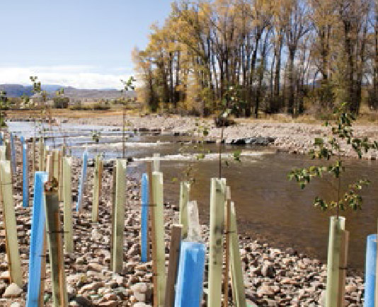
Natural Channel Design goes beyond engineering to include ecology. Structures are one component, but Rosgen argues that without restoring streamside vegetation, the river will not function. Barrineau smiles as she points out an army of blue and green tubes sticking out of the cobble. Inside each one is a native shrub or tree—river hawthorn, water birch, thinleaf alder, redosier dogwood, chokecherry, woods rose, golden current, and four willow species—all painstakingly planted in the cobble riverbank. The tubes protect the young plants from browsing and trap heat to help them grow. The toe wood and in-stream structures help guide the flow of the stream today, but healthy riparian habitat will maintain the future of the stream indefinitely.
Further up the river, two front loaders are digging out the middle of the river to create a berm channel. This will deepen the river to help move sediment during spring run-off. Berm channels, combined with cross-vane structures such as J-hooks, temporarily fix the stream profile, pattern, and dimension while the vegetation grows back. Barrineau explains these in-stream structures buy time for the plants to establish. Once the riparian ecosystem is restored, the river will no longer need human intervention to remain healthy. As we walk, I begin to see structures before Barrineau points them out: toe wood, berm channels, transplanted willow clumps, and the sculpted riverbanks. What seemed like a perfectly natural landscape is actually carefully constructed. I begin to understand something Barrineau mentioned in the beginning of our tour: “Every little elevation out here is designed for some purpose.” With these reconstruction projects complete, Barrineau will oversee monitoring to measure how these structures perform over time.
Natural Channel Design includes before and after monitoring to quantify how rivers improve. Despite such thoroughness, not everyone is onboard with these methods. In fact, the dispute over this program has become so vehement as to earn the title the “Rosgen Wars.” On one side are Rosgen and other proponents of Natural Channel Design who claim that after restoration, rivers move water and sediment more efficiently. On the other side are academic and scientific experts who argue that Natural Channel Design courses are inadequate preparation for effective stream restoration and that Rosgen’s ideas are easily misused.
Natural Channel Design’s popularity comes from its simple 40-step certification program, much easier to learn and apply than a PhD in hydrology. But critics argue the program has oversimplified extremely complex systems. Especially when people take only the first of the four certification courses or when they lack a comprehensive understanding of the philosophy, foundations, and implementation of Natural Channel Design, yet they launch into practice. This can lead to ineffective work. Perhaps the more unsettling criticism of Natural Channel Design is that peer-reviewed studies have not been able to measure its effectiveness against other methods. Even after decades of implementation, scientists have not confirmed that the work restores river ecology. Still, river restoration projects are in high demand, and many have accepted Natural Channel Design as the best available option. Until river engineers, hydrologists, and ecologists determine a better way to restore natural function to our rivers or develop a new certification process, perhaps a nationwide standard informed by the latest science, restoration projects will continue to turn to Natural Channel Design.
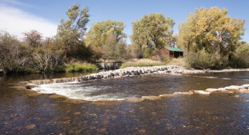
Around the next bend we come to a structure we haven’t seen before. It resembles a modified J-hook. Barrineau tells me this project, in the making since the early 2000’s, is the result of a collaboration with the local landowner. An irrigation ditch runs from the river to a nearby property. To direct the river into the ditch, the rancher maintained a push-up dam, which required annual maintenance after flooding. As a replacement for the push-up dam, Barrineau’s team built a rock cross-vane, which diverts water to the ditch even in low-flows while allowing fish to move upstream. Although Natural Channel Design focuses on restoring the natural function of a stream, it also takes into account human uses of the water.
The future of the Encampment River is promising. Barrineau and her team have assessed fifteen miles of the river, and identified several projects with potential to improve stability, fish habitat, and water delivery in the system. Barrineau hopes to continue enhancement work on the Encampment, but she recognizes the challenges. “We have huge plans. But you just have to get people to sign up and say, ‘Yeah, come out, come do this,’ because the funding is not a limiting factor anymore.” The Wyoming Wildlife and Natural Resource Trust and other organizations are eager to help fund enhancement projects as long as landowners agree to participate.
As Barrineau’s truck pulls away from the last construction site, I can’t shake the feeling that putting bulldozers and front loaders in rivers is exactly how we created sick rivers in the first place. These enhancement and restoration projects claim to be reviving our watersheds, and many believe in their power. Such projects may be healing sick waterways, but Rosgen warns, stream reconstruction is not the best option. Instead, we need better water and land management practices to avoid the damage in the first place. If we graze livestock differently or manage stream flow differently, rivers will take care of themselves. Perhaps preventing the degradation, rather than elaborate reconstruction, will be the future for river restoration and enhancement.
By Charlie Reinertsen

