This fall, the U.S. Fish and Wildlife Service will decide whether the greater sage grouse merits endangered species protection, and Wyoming is holding its breath. Thirty-seven percent of the world’s greater sage grouse call Wyoming home, and no one knows exactly what a threatened or endangered designation would mean for the agricultural and energy industries in the state. In a bid to conserve sage grouse and avert a listing, Wyoming created the Greater Sage-Grouse Core Area Protection policy meant to reduce future development in big portions of sage grouse habitat.
The policy set forth a plan to limit oil and gas, residential, and other forms of development in mapped sage grouse core habitat. To measure—and ultimately minimize—development, the state created a Density and Disturbance Calculation Tool (DDCT). Prospective developers use this geospatial program to determine whether a project will exceed the Core Area Policy “disturbance” and “disruptive activity” thresholds.
The disturbance calculation, which examines things like roads and wildfires, requires that no more than 5 percent of core sage grouse habitat is lost to development. Disruptive activities—think well pads or mining operations—are limited to an average of one per square mile. Under some conditions where valid, existing rights occur, new development may be allowed even if it exceeds the thresholds.
Two hypothetical scenarios show how the DDCT calculates disturbance and disruptions, and more importantly, leads to changes in development plans. It is up to the U.S. Fish and Wildlife Service to decide whether such changes will be enough to help slow or reverse sage grouse declines.
Gas Well Disruptive Activities
New natural gas development near a sage grouse lek comes in under the disturbance and disruption thresholds. Still, the state permitting and wildlife agencies ask the developer to keep wells at least 0.6 miles away from the lek, and to use directional drilling, drilling multiple well bores from a single well pad, to reduce surface disturbance.
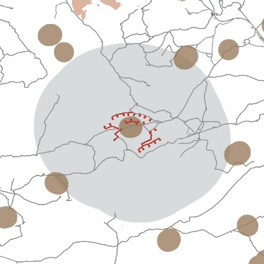 Proposed gas wells Proposed gas wellsPercent surface disturbance: 1.3 Disruptive activities per square mile: 0.23 |
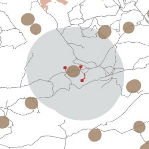 Authorized gas wells Authorized gas wellsPercent surface disturbance: 1.0 Disruptive activities per square mile: 0.04 |
Pipeline Disturbance
Some core area habitat has quite a bit of existing development. Here, a proposed pipeline would plow under enough key sage grouse habitat to push the project area over the 5 percent disturbance threshold. Rerouting the pipeline along an existing road right-of-way reduces the new surface disturbance.
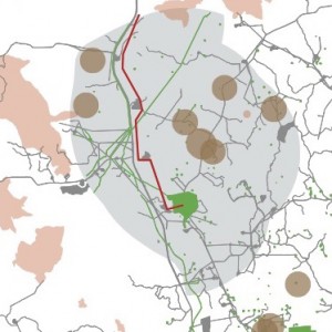 Proposed pipeline Proposed pipelinePercent surface disturbance: 5.3 Disruptive activities per square mile: 0.34 |
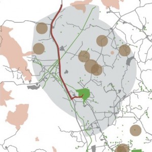 Authorized pipeline Authorized pipelinePercent surface disturbance: 4.9 Disruptive activities per square mile: 0.34 |
Text by Nicole Korfanta and Nicholas Graf, maps by Nicholas Graf and Coulter Sunderman

Pingback: Will the Greater Sage-Grouse Be Listed As An Endangered Species? | Energy Law Today