Systematic landscape planning software improves the odds against a despised invasive reed
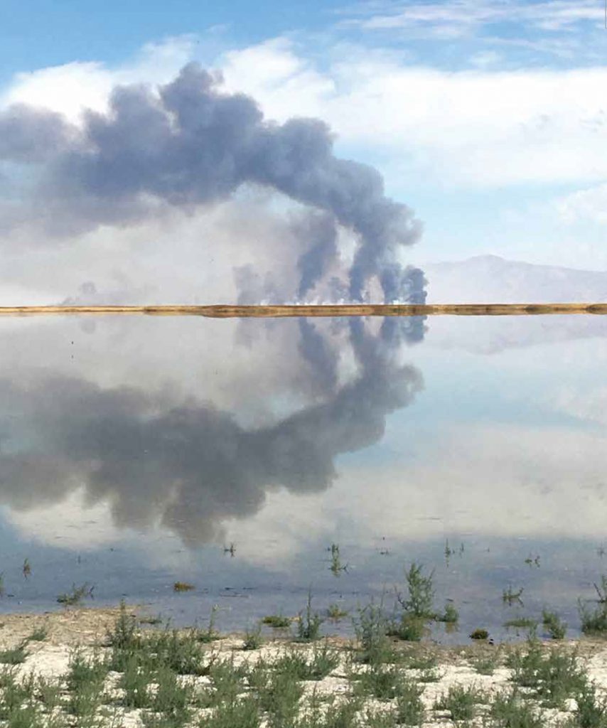
It’s a hot, sunny day in early April, and I’m out collecting GPS coordinates for stands of wetland vegetation in the Bear River Migratory Bird Refuge on the Great Salt Lake in Utah. The heat is suffocating on the swampy mudflats, but the gulls and avocets don’t seem to mind as they forage in the shallow water for brine fly larvae and other invertebrate goodies. There isn’t a cloud in the sky, until I look west and spy an ominous wall of smoke about a mile away. While smoke may be cause for concern in other managed wetlands, controlled burning is an important management technique at the Great Salt Lake. Though local air quality restrictions and wind patterns do not allow burning often, it is the most effective method for culling the unwanted invader, Phragmites australis.
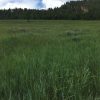
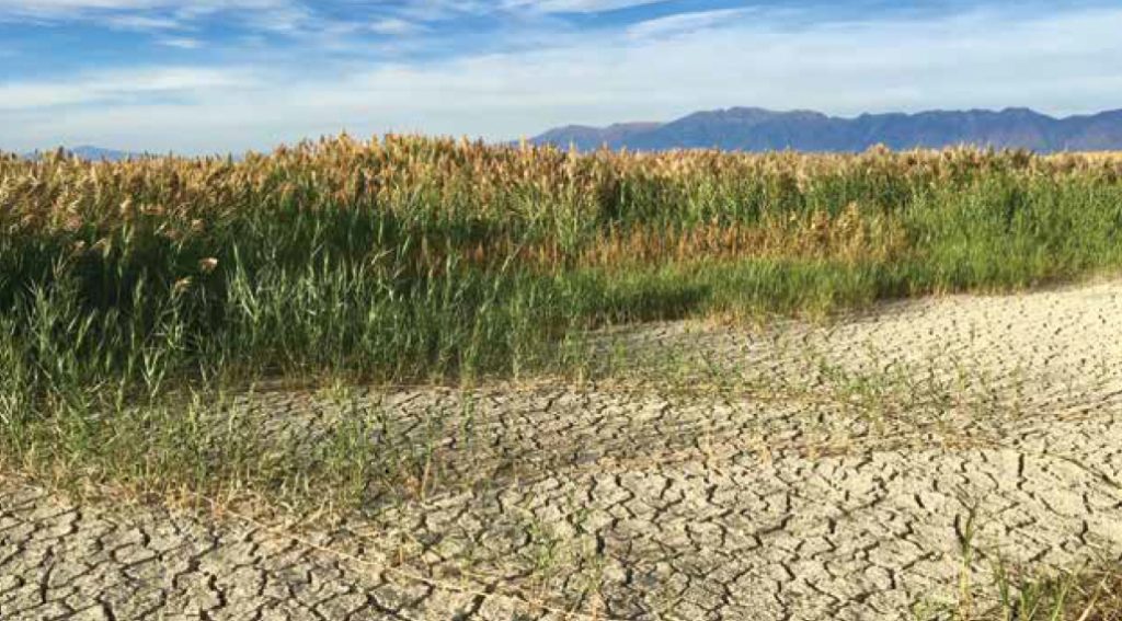
Phragmites, or “phrag” as it is commonly called, is a prolific wetland plant that grows in dense monocultures up to 15 feet high. While one subspecies of phragmites is native to Utah, an introduced, more pervasive European lineage causes land managers much more anxiety than its well-behaved native counterpart. Nonnative phragmites is despised for many reasons, including its penchant for clogging waterways, disorienting and trapping hunters within its fibrous walls, and displacing native vegetation and critical bird habitat. Its capacity to quickly populate barren patches of soil has caused a major headache for wetland managers around the Great Salt Lake and across North America.
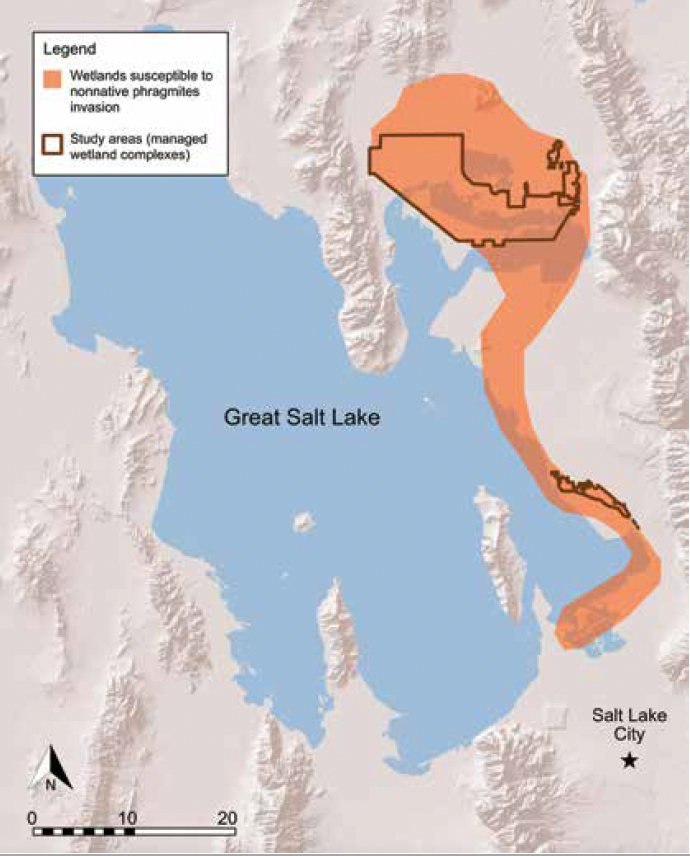
In 1983, severe flooding caused the Great Salt Lake level to rise dramatically. The briny lake water stripped most of the established vegetation away and left bare earth behind once the water receded. The invasive European strain of phragmites is a disturbance specialist. As such, in the mid to late 1980s it spread like wildfire across the eastern edge of the Great Salt Lake, encroaching wherever bare soil or shallow freshwater was found. Today, European phragmites has carpeted 24,000 acres of the eastern shore, which is almost 38 square miles altogether. Phragmites control now commands the bulk of wetland managers’ resources, including both time and money.
Since 2015, the management agency that manages the lakebed—the Utah Division of Forestry, Fire, and State Lands—has annually requested funds to manage the spread of phragmites around the Great Salt Lake. In 2019, they applied for $500,000 to treat just under 6,300 acres of invaded land, only about a quarter of the total impacted area. But, as a new study out of professor Karin Kettenring’s Wetland Ecology and Restoration Lab at Utah State University shows, successfully removing phragmites requires at least three consecutive years of repeated treatments, ongoing spot treatments of new satellite colonies, and the restoration of previously invaded areas back to native habitat. Given that managers simply do not have enough money or manpower to treat the entire phragmites-invaded area each year, how do they decide where to target their efforts? They require a methodical, data-supported process for determining where their limited management efforts will best contain phragmites and protect the remaining native wetlands.
As a graduate student at Utah State University in the Wetland Ecology and Restoration Lab, I learned about the difficulties facing wetland managers, especially in regards to justifying funding requests to contain the spread of invasive phragmites and to ensure the successful restoration of native habitat. This uphill battle may seem futile to potential funding agencies and organizations, especially without any guarantee that what land managers accomplish this year will persist through the next growing season. After talking to several land managers, I realized I could design a research project to help them address the disparity between their goals and the available resources while limiting the risk of failure for restoration projects. This research would give funders greater confidence in management actions and increase their likelihood to provide resources.
After much discussion with land managers and my thesis committee, I decided to use an approach known as systematic landscape planning to tackle this issue. Systematic landscape planning addresses conservation planning problems by identifying areas within a landscape that together meet management goals while limiting management cost and risk of failure of management actions. I decided to use the software Marxan, because it is the most widely used systematic landscape planning software in the world. It is open-source, highly customizable, easy to employ, and can process a wide variety of spatial data inputs. Marxan optimizes the selection of planning units—in this project, areas to guard against phragmites—to meet set conservation targets, like protecting bird habitat, while minimizing the management cost and risk of phragmites taking over an area. The ultimate goal for this project is to create a spatial plan-of-attack that will attain the desired goals on the landscape for the least amount of management resources and with the greatest potential for successful implementation.
To employ a Marxan optimization solution to this problem, several spatial data elements were needed, including a gridded representation of the study area, a valuation of risk associated with phragmites, management costs, and conservation targets. To create such layers, I developed cost data in accordance with local managers’ knowledge of phragmites control and water management. Next, I subdivided the study area into 1-hectare units, which is a manageable scale for local crews, yet still large enough to be impactful on the landscape. I created the risk layer by employing machine learning algorithms to classify aerial imagery into likely locations of specific wetland plant species. I then used an ecological niche model and landscape data, such as where phragmites is currently found, distance to water, and distance to disturbance, to model phragmites invasion potential across the study areas.
I then developed conservation targets with the US Fish and Wildlife Service and The Nature Conservancy—the two agencies managing these study areas. They were primarily concerned with migratory bird habitat and other ecological functions performed by wetland vegetation, such as soil carbon sequestration, heavy metal retention, and above-ground biomass. I spatially modeled these and several other ecological functions and am using them as the conservation target inputs. Marxan will run each scenario millions of times to generate a near-perfect network of planning units that meet the set targets for the least amount of cost and risk. Marxan accomplishes this objective by randomly selecting planning units until all conservation targets are met for each run. If the new run creates a management plan with less risk and cost than the previous run, it will select the new run as the “current best” and move onto the next run. It runs these random scenarios millions of times so you end up with a management plan with the lowest risk and cost based solely on data inputs. Marxan can also show the user which units were selected the most and least often. The units selected most often are critical to meet set targets while those rarely or never selected are not likely to provide much benefit. While I am still finalizing my modeled conservation targets, I expect to complete this project by fall of 2020. Through this process, I will show wetland managers which planning units they should treat given their limited resources to best meet their conservation targets while reducing the risk of phragmites undoing their on-the-ground work.
The methods developed in this study are transferable to other areas facing similar issues with invasive species, especially invasive plants. As long as land managers and planners can identify areas that are suitable to an invasive species (whether that is through mapping, using a species distribution model, or any other method), they can use the risk-aversion aspect of systematic landscape planning with Marxan to optimize their choice of treatment areas on a landscape. The other layers—cost data, a gridded study area, and conservation target data—can be as simple or complex as the project requires. This method could be used to plan treatments for other problem species in the West including purple loosestrife, cheatgrass, tamarisk, Russian olive, or other areas impacted by the dreaded phragmites. This tool can help land managers like the Bureau of Land Management, US Forest Service, National Park Service, and state agencies address the daunting task of invasive species control, which is an ever-growing nuisance in the West.
When hard decisions must be made concerning where to allocate limited resources, managers and planners can use systematic landscape planning to create a defendable management plan based on data rather than relying solely on expert or stakeholder opinion. Systematic landscape planning provides a comprehensive and transparent method for prioritizing management efforts where location information or management resources are limited and prudent decisions are required. As phragmites continues its march across Great Salt Lake wetlands and other parts of North America, managers employing this approach will have an advantage in the never-ending battle against its far-reaching roots and shoots.
Text and photos by Aubin Douglas
Aubin Douglas is a Cartography and GIS Fellow at the US Fish and Wildlife Service in Lakewood, Colorado. She is concurrently completing her second MS in the Ecology Center and Watershed Sciences Department at Utah State University. Visit karinkettenring.com to find out more about the Wetland Ecology and Restoration Lab at Utah State University.